IFD440

Model #: ABC123

Up to 4-Year Limited Warranty

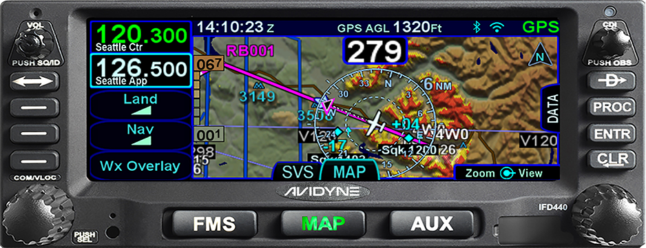
Amazing Power In A Small Chassis

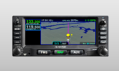
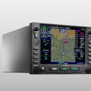
Looking to upgrade your GNS 430 with a minimum of hassle? The IFD440 is a direct slide-in upgrade utilizing the same tray and connectors as your GNS430.

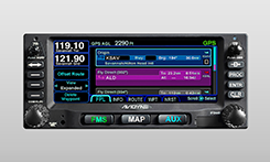
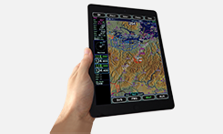
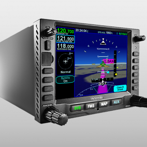
Compact and powerful, the IFD440 FMS/GPS NAV/COM is an excellent choice for general aviation and helicopters with our easy-to-use touchscreen interface and knobs and buttons when flying through turbulence. This next-generation panel-mounted navigator also makes flight planning and in-flight changes even easier because the included WiFi/Bluetooth® capabilities work seamlessly with your iPad. You’ll have big glass capabilities for a fraction of the cost.

Features


  • Full FMS/GPS/NAV/COM Capabilities
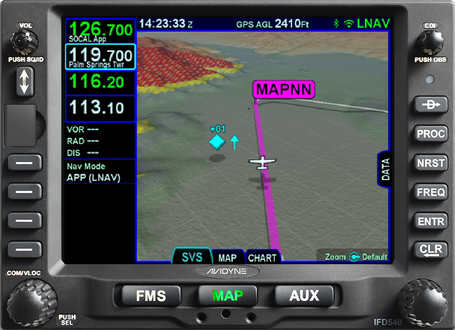
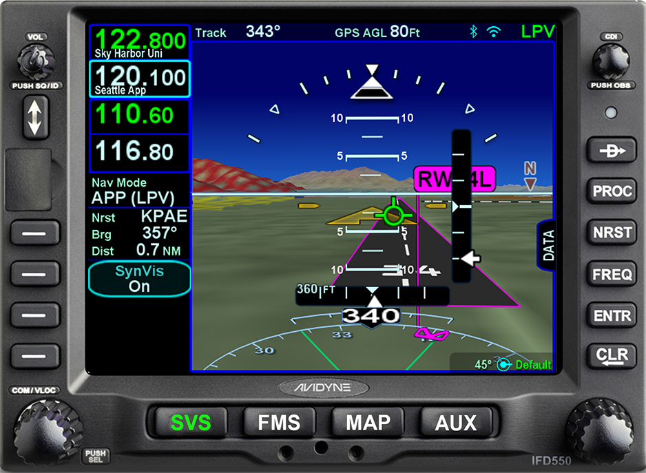
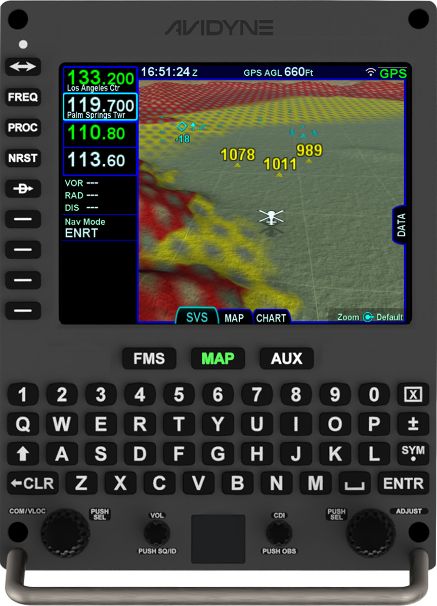
  • 3D Synthetic Vision
  • Hybrid touch user interface
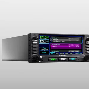
  • FMS Preview™ flight plan loading with real-time graphical depictions
  • Seamless integration to Avidyne’s IFD 100 iPad app
Display (IFD440/410)

  • 4.8” Diagonal w/Touch Screen
  • Full VGA - 640 x 480 pixels
  • 65,535 colors
  • Ultrabright sunlight readable w/LED Backlighting
Dimensions (IFD440/410)

  • Width: 6.30” (16.0cm)
  • Height: 2.66“ (11.7cm)
  • Depth: 11.00“(27.5cm) behind panel including connector
Weight (including tray and connectors)

  • IFD440 - 6.88 lb (2.34 kg)
  • IFD410 - 5.16 lb (3.99 kg)
  • IFD550 - 9.19 lb (4.17 kg)
  • IFD540 - 8.79 lb (3.99 kg)
  • IFD545 - 7.48 lb (3.39 kg)
  • IFD510 - 7.13 lb (3.23 kg)
Power Requirements

  • 11 – 33VDC
  • 4.4A/6.5A Xmit @ 14vdc
  • 2.2A/4.0A Xmit @ 28vdc
VHF COM Power Output

  • 10 Watts nominal
  • Optional 16Watt (for 28vdc installations only)
Environmental

  • DO 160E
  • To 50,000 Ft
  • -20C to +55C Operating
  • +70C Short Term
Applicable TSOs

  • TSO-C34e - ILS Glide Slope Receiving Equipment Operating within the Radio Frequency Range of 328.6-335.4 Megahertz (MHz)
  • TSO-C36e - Airborne ILS Localizer Receiving Equipment Operating within the Radio Frequency Range of 108-112 Megahertz (MHz)
  • TSO-C40c - VOR Receiving Equipment Operating within the Radio Frequency Range of 108-117.95 Megahertz (MHz)
  • TSO-C44c - Fuel Flowmeters
  • TSO-C110a - Airborne Passive Thunderstorm Detection Equipment
  • TSO-C112e - Air Traffic Control Radar Beacon System/Mode Select (ATCRBS/Mode S) Airborne Equipment
  • TSO-C113a - Airborne Multipurpose Electronic Display
  • TSO-C118 - Traffic Alert and Collision Avoidance System (TCAS) Airborne Equipment, TCAS I
  • TSO-C128a - Devices that Prevent Blocked Channels Used in Two-Way Radio Communications Due to Unintentional Transmissions
  • TSO-C146d - Stand-Alone Airborne Navigation Equipment Using the Global Positioning System (GPS) Augmented by the Wide Area Augmentation System (WAAS).Airborne Supplemental Navigation Equipment Using the Global Positioning System (GPS) - Gamma 3
  • TSO-C147 - Traffic Advisory System (TAS) Airborne Equipment - Class A (Display Functions Only)
  • TSO-C157a - Aircraft Flight Information Services – Broadcast (FIS-B) Datalink Systems and Equipment
  • TSO-C165 - Electronic Map Display Equipment for Graphical Depiction of Aircraft Position
  • TSO-C169a - VHF Radio Communications Transceiver Equipment Operating Within The Radio Frequency Range 117.975 To 137.000 Megahertz - Class C, E, 3 and 5

This list is not exhaustive - click here for a full list of compatible equipment.

Satellite Datalink Weather Interface

  • Avidyne MLB700/WSI AV-300 Broadcast Datalink Receiver
  • GDL69/A XM Broadcast Datalink using Baron Wx Services and XM® Satellite Receiver

Electronic Approach Charts & Airport Diagrams (IFD5XX Only)

  • CMax™ – Jeppesen Electronic Airway Manual Charts (IFD540 only)
  • European VFR (Bottlang) Charts - optional
Charts, Nav Data, and other software updates are easily field loadable via USB port.

Lightning Interface

  • Avidyne TWX670 Tactical Lightning Detection
  • L3 WX-500 Stormscope® Weather Mapping Sensor

Wx Radar Systems

  • Bendix/King RDR2000

Traffic Interface

  • Avidyne SkyTrax600/605/610/615/620/A TAS/AXP322 TIS
  • Ryan 9900B/BX TAS
  • Honeywell KTA870/KMH880 TAS/IHAS/CAS66A TCAS I
  • L3 Skywatch 497 / HP TAS/ 791 TCAS I
  • Garmin GTS800/820 TAS/GTS850 TCAS I/ GTX330 TIS

ADS-B Interface

  • Avidyne SkyTrax605A/SkyTrax615A/ SkyTrax620A (Traffic)
  • Avidyne SkyTrax100B
  • Avidyne AXP340, AXP322
  • L3 NGT-9000
  • FreeFlight RANGR
  • Garmin GTX330ES, GTX335, GTX345

Terrain Awareness

  • Color-Contoured Terrain Base Map Built in
  • Americas Terrain & US Obstacle Data
  • International Terrain Data (optional)

406 ELT Interface

  • Aviation RS-232
  • NMEA 0183

Applicable TSOs

  • TSO-C34e, TSO-C36e, TSO-C40c, TSO-C44c, TSO-C110a, TSO-C112e, TSO-C113a, TSO-C118, TSO-C128a, TSO-C146d, TSO-C147, TSO-C157a, TSO-C165, TSO-C169a

Service Letter – UNCOMMANDED RESTART IFD4XX IFD5XX

Date: 09/15/2021
Part Number: 606-00182-032
File Size: 231.98 KB
File Revision:

Service Letter – INCORRECT SQUAWK CODE WHEN IFD4XX/5XX IS THE CONTROLLER OF THE NGT9000R.

Date: 03/05/2021
Part Number:
File Size: 145.77 KB
File Revision:

IFD440 Quick Reference Guide

Date: 08/25/2020
Part Number:
File Size: 9.4mb
File Revision:

AVIDYNE PRODUCT BROCHURE

Date: 08/27/2019
Part Number: AV848
File Size: 16.3 MB
File Revision: Rev. 02

IFD4XX PILOTS GUIDE

Date: 08/27/2019
Part Number: 600-00304-000
File Size: 9.14 MB
File Revision: Rev. 07

Comparison Chart

IFD440

FMS/GPS NAVIGATOR

IFD540 FMS/GPS NAVIGATOR

IFD550 PREMIUM FMS/GPS/NAV/COM

AVIDYNE HELIOS™

AVIDYNE ATLAS™

FMS/GPS

VHF NAV

VHF COM

3D SVS

ARS + DYNAMIC SVS

N/A

N/A

WIFI/BT

RADAR

FROM 5-SERIES

FROM 5-SERIES

OPTIONAL

OPTIONAL

OPTIONAL

VIDEO

FROM 5-SERIES

FROM 5-SERIES

OPTIONAL

OPTIONAL

OPTIONAL